NCERT Solutions for class 9 Social Science Geography Chapter 2 Physical features of India
NCERT Solutions for class 9 Social Science Geography Chapter 2 Physical features of India
NCERT Solutions for class 9 Geography SST Chapter 2 Physical features of India
Question-1
What are Tectonic Plates?
Solution:
The crust (upper part) of the earth has been formed out of seven major and some minor plates. These are called tectonic plates.
A Tectonic plate (also called lithospheric plate) is a massive, irregularly shaped slab of solid rock, generally composed of both continental and oceanic lithosphere. Plate size can vary greatly, from a few hundred to thousands of kilometers across; the Pacific and Antarctic Plates are among the largest. Plate thickness also varies greatly, ranging from less than 15 km for young oceanic lithosphere to about 200 km or more for ancient continental lithosphere.
Question-2
Which continents of today were part of the Gondwana land?
Solution:
The oldest landmass, (the Peninsula part), was a part of the Gondwana land. The Gondwana land included India, Australia, South Africa and South America as one single land mass.
Question-3
What is the bhabar?
Solution:
The rivers, after descending from the mountains deposit pebbles in a narrow belt of about 8 to 16 km in width lying parallel to the slopes of the Shiwaliks. It is known as bhabar.
Question-4
Distinguish Between Converging and Diverging Tectonic Plates
Solution:
Converging Tectonic Plates: Some plates come towards each other and form convergent boundaries.
Diverging Tectonic Plates: Some plates move away from each other and form divergent boundaries.
Question-5
Distinguish Between Bhangar and Khadar
Solution:
Bhangar:
The largest part of the northern plain is formed of older alluvium They lie above the flood plains of the rivers and present a terrace-like feature. This part is known as bhangar.
Khadar:
The soil in this region contains calcareous deposits locally known as kankar. The newer, younger deposits of the flood plains are called khadar. They are renewed almost every year and so are fertile, thus, ideal for intensive agriculture.
Question-6
Distinguish Between the Western Ghats and the Eastern Ghats
Solution:
Western Ghats:
The Western Ghats are higher than the Eastern Ghats. Their average elevation is 900– 1600 metres as against 600 metres of the Eastern Ghats. The Western Ghats cause orographic rain by facing the rain bearing moist winds to rise along the western slopes of the Ghats. The Western Ghats are known by different local names. The height of the Western Ghats progressively increases from north to south. The highest peaks include the Anai Mudi (2,695metres) and the Doda Betta (2,637 metres).
Eastern Ghats:
The Eastern Ghats stretch from the Mahanadi Valley to the Nigiris in the south. The Eastern Ghats are discontinuous and irregular and dissected by rivers draining into the Bay of Bengal. Mahendragiri (1,501 metres) is the highest peak in the Eastern Ghats. Shevroy Hills and the Javadi Hills are located to the southeast of the Eastern Ghats.
Question-7
Describe how the Himalayas were formed.
Solution:
The Himalayas and the Northern Plains are the most recent landforms. From the viewpoint of geology, Himalayan Mountains form an unstable zone. The whole mountain system of Himalaya represents a very youthful topography with high peaks, deep valleys and fast flowing rivers. The northern plains are formed of alluvial deposits. The peninsular plateau is composed of igneous and metamorphic rocks with gently rising hills and wide valleys.
Question-8
Which are the major physiographic divisions of India? Contrast the relief of the Himalayan region with that of the Peninsular plateau.
Solution:
The physical features of India can be grouped under the following physiographic divisions:
- The Himalayan Mountains
- The Northern Plains
- The Peninsular Plateau
- The Indian Desert
- The Coastal Plains
- The Islands
The Himalaya consists of three parallel ranges in its longitudinal extent. A number of valleys lie between these ranges. The northernmost range is known as the Great or Inner Himalayas or the ‘Himadri’. It is the most continuous range consisting of the loftiest peaks with an average height of 6,000 metres. It contains all the prominent Himalayan peaks.
The Deccan Plateau is a triangular landmass that lies to the south of the river Narmada. The Satpura range flanks its broad base in the north while the Mahadev, the Kaimur hills and the Maikal range form its eastern extensions. Locate these hills and ranges in the physical map of India. The Deccan Plateau is higher in the west and slopes gently eastwards. An extension of the Plateau is also visible in the northeast– locally known as the Meghalaya and Karbi-Anglong Plateau. It is separated by a fault from the Chotanagpur Plateau. Three Prominent hill ranges from the west to east are the Garo, the Khasi and the Jaintia Hills.
Question-9
Give an account of the Northern Plains of India.
Solution:
The northern plain has been formed by the interplay of the three major river systems, namely– the Indus, the Ganga and the Brahmaputra along with their tributaries. This plain is formed of alluvial soil. The deposition of alluvium in a vast basin lying at the foothills of the Himalaya over millions of years, formed this fertile plain. It spreads over an area of 7 lakh sq. km. The plain being about 2400 Km long and 240 to 320 Km broad is a densely populated physiographic division. With a rich soil cover combined with adequate water supply and favourable climate, it is agriculturally a very productive part of India.
The rivers in their lower course split into numerous channels due to the deposition of silt. These channels are known as distributaries. The Northern Plain is broadly divided into three sections. The Western part of the Northern Plain is referred to as the Punjab Plains. Formed by the Indus and its tributaries, the larger part of this plain lies in Pakistan. The Indus and its tributaries–the Jhelum, the Chenab, the Ravi, the Beas and the Satluj originate in the Himalaya. This section of the plain is dominated by the doabs.
Question-10
Write short notes on the following.(i) The Indian Desert, (ii) The Central Highlands (iii) The Island Groups of India
Solution:
(i) The Indian Desert
The Indian desest lies towards the western margins of the Aravali Hills. It is an undulating sandy plain covered with sand dunes. This region receives very low rainfall below 150 mm per year. It has arid climate with low vegetation cover. Streams appear during the rainy season. Soon after they disappear into the sand as they do not have enough water to reach the sea. Luni is the only large river in this region. Barchans (crescent-shaped dunes) cover larger areas but longitudinal dunes become more promiment near the Indo-Pakistan boundary.
(ii) The Central Highlands
The Peninsular plateau consists of two broad divisions, namely, the Central Highlands and the Deccan Plateau. The part of the Peninsular plateau lying to the north of the Narmada river covering a major area of the Malwa plateau is known as the Central Highlands. The Vindhyan range is bounded by the Central Highlands on the south and the Aravalis on the northwest. The further westward extension gradually merges with the sandy and rocky desert of Rajasthan.
The flow of the rivers draining this region, namely the Chambal, the Sind, the Betwa and Ken is from southwest to northeast, thus indicating the slope. The Central Highlands are wider in the west but narrower in the east. The eastward extensions of this plateau are locally known as the Bundelkhand and Baghelkhand. The Chotanagpur plateau marks the further eastward extension, drained by the Damodar river.
(iii) The Island Groups of India
This group of islands is composed of small coral islands. Earlier they were known as Laccadive, Minicoy and Amindive. In 1973 these were named as Lakshadweep. It covers small area of 32 sq km. Kavaratti island is the administrative headquarters of Lakshadweep.
This island group has great diversity of flora and fauna. The Pitli Island, which is uninhabited, has a bird sanctuary. An elongated chain of islands located in the Bay of Bengal extending from north to south. These are Andaman and Nicobar islands. They are bigger in size and are more numerous and scattered. The entire group of islands is divided into two broad categories – The Andaman in the north and the Nicobar in the south. It is believed that these islands are an elevated portion of submarine mountains. These island groups are of great starategic importance for the country. There is great diversity of flora and fauna in this group of islands too. These islands lie close to the equator and experience equatorial climate and has thick forest cover.
NCERT Solutions for Class 9 Social Science Geography Chapter 2 Physical Features of India
Question 1.
Choose the right answer from the four alternatives given below:
(i) A landmass bounded by sea on three sides is referred to as
(a) Coast
(b) Island
(c) Peninsula
(d) None of the above
Ans. (c) Peninsula
(ii) Mountain ranges in the eastern part of India forming its boundary with Myanmar are collectivity called
(a) Himachal
(b) Uttarakhand
(c) Purvachal
(d) None of the above
Ans. (c) Purvachal
(iii) The western coastal strip, south of Goa is referred to as
(a) Coromandel
(b) Konkan
(c) Kannad
(d) Northern Circar
Ans. (c) Kannad
(iv) The highest peak in the Eastern Ghats is
(a) Anai Mudi
(b) Kanchenjunga
(c) Mahendragiri
(d) Khasi
Ans. (c) Mahendragiri
Get free NCERT Solutions for Class 9 Social Science Geography Chapter 2 Physical Features of India solved by experts.
Question 2.
Answer the following questions briefly.
(i) What are tectonic plates?
Ans. Large fragments of the earth’s crust torn due to the rising convectional currents are called tectonic plates.
(ii) Which continents of today were part of the Gondwana land?
Ans. The continents are South America, South Africa, Australia and Antarctica.
(iii) What is the bhabar?
Ans. Bhabar is a narrow belt of the Ganga plain covered with pebbles lies along the foothills of the Shiwaliks.
(iv) Name the three major divisions of the Himalayas from north to south.
Ans. (a) The Greater Himalayas or Himadri (Inner Himalayas)
(b) Himachal or Lesser Himalayas (Middle Himalayas)
(c) The Shiwaliks (Outer Himalayas)
(v) Which plateau lies between the Aravali and the Vindhyan ranges?
Ans. Malwa plateau lies between the Aravali and the Vindhyan range.
(vi) Name the island group of India having coral origin.
Ans. Lakshadweep islands is the island group having coral origin.
Question 3.
Distinguish between:
(i) Converging and diverging tectonic plates
Ans:
| Converging Plates | Diverging Plates |
| (a) When tectonic plates come towards each other,they are called converging plates. | (a) When tectonic plates move away from each other, they are called diverging plates. |
| (b) When they come towards each other, they either collide and crumble or one of them slides under the other. | (b) When they move away from each other, they do not collide or crumble. |
| (c) Converging plates cause folding. | (c) The diverging plates cause cracks or fractures on the earth’s curst. |
(ii) Bhangar and Khadar
Ans:
| Bhangar | Khadar |
| (a) This is a highland composed of old alluvium. | (a) This is a lowland composed of new alluvium. |
| (b) It is always above the level of flood plain. | (b) It is flooded almost every year and new alluvium is deposited. |
| (c) It is often saturated with calcareous nodules known as kankar. | (c) It is often characterised by clay soil, which is very fertile. |
| (d) This is not much suited for cultivation. | (d) It is ideal for intensive agriculture. |
(iii) Western Ghats and Eastern Ghats
Ans:
| Western Ghats | Eastern Ghats |
| (a) Western Ghats mark the western edge of the Deccan Plateau. | (a) Eastern Ghats mark the eastern edge of the Deccan Plateau. |
| (b) They are continuous and can only be crossed through passes only, e.g., Pal Ghat, Bhor Ghat etc. | (b) They are discontinuous and irregular and have been dissected by the rivers draining into the Bay of Bengal. |
| (c) They lie parallel to the Western coast along the Arabian Sea. | (c) They lie along the eastern coast along the Bay of Bengal. |
| (d) They are higher in south and the height increases towards the south. | (d) They are higher in the north and the height increases towards the north. |
| (e) Average height is between 900 m to 1600 m. | (e) Average height is 600 m. |
| (f) The highest peak is Anai Mudi with height of 2,695 m above sea level. | (f) The highest peak is Mahendragiri with height of 1,501 m above the sea level. |
Question 4.
Describe how the Himalayas were formed.
Answer:
(a) The oldest landmass of India (i.e. Peninsular part) was a part of Gondwana land, which included India, Australia, South Africa and South America as one single landmass.
(b) Convectional currents split the earth’s crust into’a number of fragments, thereby leading to the drifting of the Indo – Australian plate towards the north after being separated from Gondwana land.
(c) The northward drift resulted in the collision of this plate with much larger Eurasian plate.
(d) Due to this collision, the sedimentary rocks which were accumulated in the geosyncline called the Tethys, were folded to form the mountain systems of west Asia and Himalayas.
(e) The Himalayas represent a youthful topography with high peaks, deep valleys and fast-flowing rivers.
Question 5.
Which are the major physiographic divisions of India? Contrast the relief of the Himalayan region with that of the Peninsular plateau.
Answer:
The major physiographic divisions of India are:
- The Himalayan Mountains
- The Northern Plains of India
- The Peninsular Plateau
- The Indian Desert
- The Coastal Plains
- The Islands
| Relief of Himalayan Region | Relief of Peninsular Plateau |
| (a) Himalayas are young fold and loftiest mountains of the world comprising of several parallel ranges. | (a) It is a high tableland made up of old crystalline igneous and metamorphic rocks. |
| (b) They were formed due to folding of sedimentary rock strata in the bed of the Tethys Sea. | (b) The Peninsular Plateau was born by breaking up of the Gondwana land. |
| (c) This region consists of the highest peaks of the world. Many of these peaks are above 6000 metres and snow covered throughout the year, e.g., Mt. Everest, Mt. K2 etc. | (c) The hills of the Peninsular Plateau are rounded due to large scale erosion over a long period of time e.g., Aravalis and the Nilgiris etc. |
| (d) The Himalayas represent a youthful topography with high peaks, gorges, deep valleys and waterfalls. | (d)The Peninsular Plateau represents a relief of rounded hills, broad and shallow valleys. |
Question 6.
Give an account of the Northern Plains of India.
Answer:
- (a) The Northern Plains of India are alluvial plains of India. They are formed by the sediments brought from the mountains and deposited by the rivers in the depression formed after the uplift of the Himalayas namely the Indus, Ganga and Brahmaputra and their tributaries.
- (b) The plains spreads over an area of 7 lakh sq. km. The length of this plain is 2,400 km long and 240 km broad.
- (c) It is densely populated and intensely cultivated area.
- (d) With adequate water supply and favourable climate, it is agriculturally a very productive part of India.
- (e) The Northern Plains of India are divided into three divisions.
- Punjab Plains covers the western part of the Northern plains. They are formed by Indus river and its tributaries.
- Ganga Plains extends between Ghaggar and the Teesta river, spread over the states of Haryana, Delhi, UP, Bihar, Jharkhand and West Bengal.
- The Brahmaputra Plain lies to the east of the Ganga plains. It covers the area of Assam.
Question 7.
Write short notes on the following:
(a) The Indian Desert
Ans. (a) The Indian desert lies to the west of the Aravali hills. It is an uneven sandy plain covered with sand dunes.
(b) Barchans (crescent-shaped sand dunes) cover a larger part of the desert. Near the Indo-Pakistan border, longitudinal sand dunes are more common.
(c) It has arid climate with scarce vegetation and rainfall below 150 mm per year.
(d) Rivers/streams appear only during the rainy season and soon afterward disappear in the sand. They do not have enough water to reach the sea. JRiver Luni is the only large river in this area.
(b) The Central Highlands
Ans. (a) The Part of the Peninsular plateau lying north of the Narmada river is called Central Highlands. These highlands are made up of hard igneous and metamorphic rocks.
(b) It is bordered by Aravali range to the north-west. The Central Highlands include the Malwa plateau to the west and Chotanagpur plateau to the east.
(c) The Central Highlands are wider in the west and become narrow eastwards. The eastward extension of the Malwa plateau is locally called Bundelkhand and Baghelkhand. Chotanagpur plateau in the east is drained by Damodar river, a southern tributary of Ganga river.
(c) The Island Groups of India
Ans. India has two groups of islands namely:
(a) Lakshadweep Islands
(b) Andaman and Nicobar islands group
Lakshadweep Islands:
(a) These island groups are located in the Arabian Sea i.e., west of Malabar coast of Kerala.
(b) These islands are of coral origin formed by deposition of the dead remains,
(c) The total area of islands are 32 sq km. In Lakshadweep, administrative headquarters is in Kavaratti islands.
(d) They have a wide diversity of flora and fauna. The Pitti island, an uninhabited island has a bird sanctuaiy.
Andaman and Nicobar Island:
(a) These islands are located in the Bay of Bengal are the raised portion of the submerged mountain ranges projecting out of the sea water.
(b) Large in size and are more numerous. Some of them are of volcanic origin e.g. Barren island the only active volcano,
(c) These islands are of strategic importance as it lies very close to south-east Asia,
(d) The capital city is Port Blair,
(e) Experience equatorial climate and has thick forest cover.
Question 8.
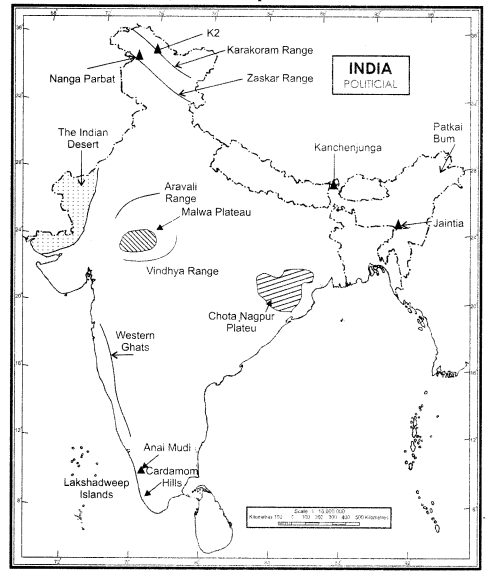
On an outline map of India show the following.
(i) Mountain and hill ranges – the Karakoram, the Zaskar, the Patkai Bum, the Jaintia, the Vindhya range, the Aravali and the Cardamom hills.
(ii) Peaks – K2, Kanchenjunga, Nanga Parbat and Anai Mudi.
(iii) Plateaus – Chotanagpur and Malwa
(iv) The Indian Desert, Western Ghats, Lakshadweep Islands.
Answer: