NCERT Solutions for class 9 Social Science Geography Chapter 3 Drainage Questions
NCERT Solutions for class 9 SST Geography Chapter 3 Drainage Questions
Question-1
What is meant by the water divide? Give an example.
Solution:
Any elevated area, such as a mountain or upland, separates two drainage basins. Such upland is known as the water divide. Ambala is located on the water divide between the Indus and the Ganga river systems.
Question-2
Which is the largest river basin in India?
Solution:
The Ganga basin is the largest basin in India.
Question-3
Where do the rivers Indus and Ganga have their origin?
Solution:
The headwaters of the Ganga called the ‘Bhagirathi’ is fed by the Gangotri Glacier and joined by the Alaknanda at Devaprayag in Uttaranchal. At Haridwar, the Ganga emerges from the mountains on to the plains. The Indus flows through Baltistan and Gilgit and emerges from the mountains at Attock.
Question-4
Name the two headstreams of the Ganga. Where do they meet to form the Ganga?
Solution:
Alakananda and Bhagirathi are the two headstreams of the Ganga. They meet at Devaprayag.
Question-5
Why does the Brahmaputra in its Tibetan part have less silt, despite a longer course?
Solution:
The Brahmaputra river, which is known as Tsangpo in Tibet, receives a very little volume of water in Tibet so it has less silt there. On the other hand, this very river when enters India it passes through such a region which receives heavy rainfall. As such in India, it carries a large volume of water and a larger amount of silt.
Question-6
Which two Peninsular rivers flow through trough?
Solution:
Narmada and Tapi are the two Peninsular rivers, which flow through the trough.
Question-7
Discuss the significant difference between the Himalayan and the Peninsular rivers.
Solution:
The Himalayan Rivers The Peninsular or Deccan Rivers
1. The Himalayan rivers rise in the snow-covered mountains as such they flow throughout the year. The mountains in which the Deccan rivers rise are not snow-covered. Hence they dry up in summer.
2. The Himalayan rivers flow in leveled Northern Plains. Therefore, they are quite useful for navigation and irrigation. The Peninsular rivers flow on the uneven rocky surface. Therefore they are neither navigable nor useful for irrigation.
3. The Himalayan rivers bring with them fertile alluvium which they deposit in the Indo-Gangetic Plains. The Peninsular rivers do not bring with them enough alluvium. As the current is swift so the deposition activity is negligible.
4. Canals have been dug to use the water of these rivers for irrigation. As the terrain is rocky and the banks of these rivers are high, canals cannot be dug. However, dams are built to store the floodwater for irrigation with the help of small channels.
5. Many important towns and centres of trade are situated on the banks of these rivers. Very few important towns and centres of trade are situated on the banks of these rivers.
6. The porous soil absorbs a lot of water, which is later on used as groundwater by digging wells and tube wells for domestic and irrigation purposes. The rocky soil does not absorb any water. Hence no wells can be dug. All the water flows down the sea at one and the same time.
Question-8
Compare the east-flowing and the west-flowing rivers of the Peninsular plateau.
Solution:
East Flowing Rivers
The Mahanadi, the Godavari, the Krishna, and the Kaveri are the main east flowing rivers of Peninsular India. These rivers drain in the Bay of Bengal. These rivers make deltas at their mouth
West Flowing Rivers.
These rivers have a developed tributary system. Their tributaries are comparatively large in size. These rivers flow through not very deep channels.
The Narmada and the Tapi are the main west-flowing rivers of Peninsular India. These rivers drain in the Arabian Sea. These rivers enter the sea through estuaries. These rivers are devoid of developed tributary system. Their tributaries are quite small in size. These rivers flow in a trough or a funnel-like narrow but deep channel.
Question-9
Why are rivers important for the country’s economy?
Solution:
Rivers have been of fundamental importance throughout human history. Water from the rivers is a basic natural resource, essential for various human activities. Therefore, the riverbanks have attracted settlers from ancient times. These settlements have now become big cities. Make a list of cities in your state, which is located on the bank of a river. Using rivers for irrigation, navigation, hydropower generation is of special significance – particularly to a country like India, where agriculture is the major source of livelihood of the majority of its population.
NCERT Solutions for Class 9 Social Science Geography Chapter 3 Drainage
Question 1.
Choose the right answer from the four alternatives given below.
(i) Which one of the following describes the drainage patterns resembling the branches of a tree?
(a) Radial
(b) Dendritic
(c) Centrifugal
(d) Trellis
ans.
(b) Dendritic pattern.
(ii) In which of the following states is the Wular lake located?
(a) Rajasthan
(b) Uttar Pradesh
(c) Punjab
(d) Jammu and Kashmir
ans.
(d) Jammu and Kashmir state.
(iii) The river Narmada has its source at
(a) Satpura
(b) Brahmagiri
(c) Amarkantak
(d) Slopes of Western Ghats
Ans.
(c) Amarkantak
(iv) Which one of the following lakes is a salt water lake?
(a) Sambhar
(b) Dal
(c) Wular
(d) Gobind Sagar
Ans.
(a) Sambhar lake
(v) Which one of the following is the longest river of the Peninsular India?
(a) Narmada
(b) Krishna
(c) Godavari
(d) Mahanadi
Ans.
(c) Godavari river
(vi) Which one amongst the following rivers flows through a rift valley?
(a) Mahanadi
(b) Thngabhadra
(c) Krishna
(d) Tapi
Ans.
(d) Tapi river
Question 2.
Answer the following questions briefly.
(i) What is meant by a water divide? Give an example.
Ans. Water divide is an elevated area, such as a mountain or an upland, that separates two drainage basins. For example, the water divide between the Indus and the Ganga river system is Ambala.
(ii) Which is the largest river basin in India?
Ans. Ganga river basin is the largest one in India. The length of this basin is over 2,500 km.
(iii) Where do the rivers Indus and Ganga have their origin?
Ans. The river Indus has its origin in Tibet, near Mansarowar lake. The Ganga river originates at the Gangotri Glacier on the sourthern slopes of the Himalayas.
(iv) Name the two headstreams of the Ganga. Where do they meet to form the Ganga?
Ans. The two headstreams of the Ganga are—the Bhagirathi and the Alaknanda. They meet to form the Ganga at Devaprayag in Uttarakhand.
(v) Why does the Brahmaputra in its Tibetan part have less silt, despite a longer course?
Ans. The Brahmaputra in its Tibetan part carries a smaller volume of water and less silt as it is a
cold and dry area.
(vi) Which two peninsular rivers flow through trough?
Ans. The Narmada and the Tapi are the two peninsular rivers that flow through trough.
(vii) State some economic benefits of rivers and lakes.
Ans.
Economic benefits of rivers:
- Rivers provide water which is a basic natural resource for various human activities.
- They are used for irrigation, navigation and generation of hydroelectric power.
- They have a moderating influence on the climate of the surroundings and maintain the aquatic ecosystem.
Economic benefits of lakes:
- They help to regulate the flow of a river.
- They prevent flooding at times of heavy rainfall and during the dry season, they help to maintain an even flow of water.
- They also have a moderating influence on the surrounding climatic conditions and maintain the aquatic ecosystem.
- They enhance the natural beauty and recreational activities by encouraging tourism.
- Lakes are also used for the generation of hydroelectricity.
Question 3.
Below are given names of a few lakes of India. Group them under two categories- natural and created by human beings:
(a) Wular
(b) Dal
(c) Nainital
(d) Bhimtal
(e) Gobind Sagar
(f) Loktak
(g) Barapani
(h) Chilika
(i) Sambhar
(j) Rana Pratap Sagar
(k) Nizam Sagar
(l) Pulicat
(m) Nagarjuna Sagar
(n) Hirakund
Answer:
Natural Lakes:
(a) Wular
(b) Dal
(c) Nainital
(d) Bhimtal
(f) Loktak
(g) Barapani
(h) Chilika
(i) Sambhar
(l) Pulicat
Lakes Created human beings:
(e) Gobind Sagar
(j) Rana Pratap Sagar
(k) Nizam Sagar
(m) Nagarjuna Sagar
(n) Hirakund
Question 4.
Discuss the significant difference between the Himalayan and the Peninsular rivers.
Answer:
| The Himalayan Rivers | The Peninsular Rivers |
| (i)They are perennial rivers. They get water from both the melted snow and of heavy rainfall. | (a)They are seasonal in nature. They depend on rainfall only. |
| (ii)They perform an immense erosional activity in the upper course. | (b)They do not perform any erosional activity in the upper course. |
| (c)They have long courses from their source to the mouth. | (c)They have shorter and shallower course. |
| (d)They carry large amount of silt and sand, which is renewed every year by annual floods. Therefore they are good for agriculture. | (d)These river do not carry much silt, there are no major plains. Fertile lands are only found in the small delta areas. |
| (e)The Ganga, the Indus, the Brahmaputra are major Himalayan rivers. | (e)The Mahanadi, the Godavari, the Krishna, the Kaveri, the Narmada and the Tapi are major Peninsular rivers. |
Question 5.
Compare the east-flowing and the west-flowing rivers of the Peninsular plateau.
Answer:
| The East Flowing Rivers | The West Flowing Rivers |
| (i)The Mahanadi, the Godavari, the Krishna, and the Kaveri are the east-flowing rivers of Peninsular India. | (i)The Narmada and the Tapi are the major west-flowing rivers of Peninsular India. |
| (ii)These rivers drain into the Bay of Bengal. | (ii)These rivers drain into the Arabian Sea. |
| (iii)These rivers form deltas on the east coast. | (iii)These rivers form estuaries on the west coast. |
| (iv)These rivers have a developed and large tributary system. | (iv)These rivers are devoid of any developed tributary system. |
Question 6.
Why are rivers important for the country’s economy?
Answer:
Rivers are important for a country’s economy in the following ways:
- The rivers provide water as the basic resource that is used for various activities.
- The river banks have attracted settlers from ancient times. These settlements have now become major cities.
- Rivers provide water for irrigation, navigation, and for the generation of hydroelectric power.
- The rivers have also promoted agriculture, the most important economic activity of a country.
- The rivers tend to have a moderating influence on the climate of the surroundings. They also help to maintain the aquatic ecosystem.
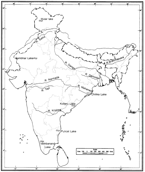
Map Skills
(i) On the outline map of India mark and label the following rivers: Ganga, Satluj, Damodar, Krishna, Narmada, Tapi, Mahanadi, and the Brahmaputra.
(ii) On an outline map of India mark and label the following lakes: Chilika, Sambhar, Wular, Pulicat, Kolleru.